

FFIEC Geocoding: Concept, Importance and Alternative
Financial institutions in the U.S., such as credit unions, insurance companies, etc. need to adhere to regulations and standards by The Federal Financial Institutions Examination Council (FFIEC). It helps protect consumers and ensure the stability of the financial system.
One such standard that FFIEC enforces to help financial institutions meet their legal reporting obligations is to generate FFIEC geocode. It assists with compliance and regulatory reporting. Although granular, the FFIEC geocoding system has disadvantages like being unable to identify spelling mistakes.
An address verification system that comes with a geocoding API would be a better alternative to the FFIEC Geocoding System. It will improve the address accuracy, and ensure that the address is standardized.
This blog will cover the basics of FFIEC Geocoding, diving deep into FFIEC. We will also take a look at its disadvantages and how address verification makes for a superior choice.
Key Takeaways
- FFIEC Geocoding System is an online tool that provides financial entities like banks, insurance companies, and real estate agents with the address and geocode information. It assists them with compliant reporting.
- It is an easy-to-use system, however, it has its limitations. It does not provide any information about longitudes, and latitudes. Moreover, in the event of a misspelling, it might return the wrong information.
- A geocoding API will be a suitable alternative to the FFIEC Geocoding System. With quick integration, it will provide geocodes of a valid address, ensuring high data quality for regulatory reporting.
- PostGrid’s address verification tool comes with a geocoding API. It enhances address accuracy by providing longitudes and latitudes. Moreover, its bulk address verification and geocoding save time.
What is FFIEC Geocoding?
FFIEC geocoding is the computational process of transforming a physical address into geographic elements and geocodes. The tool used for its calculation is called the FFEIC Geocoding System. It is a web application used by financial institutions to determine the address information and geocodes. It helps them stay compliant while reporting mortgages, business loans, and farm loans. It was created by FFIEC to help financial institutions that fall under the Home Mortgage Disclosure Act (HMDA) and Community Reinvestment Act (CRA) meet the reporting regulation requirements.
The FFIEC Geocoding System provides address-related and geocode information. The institutions are required to include the following details when they create a report for loans.
- State name with 2-digit FPIS code: An FPIS code is a distinctive number that uniquely identifies a geographical region such as a state or a county.
- County name with 3-digit FPIS code.
- Metropolitan Statistical Area (MSA) Number: It is a five-digit number that represents the geographical area consisting of a city or an urbanized area with at least a population of 50,000. It consists of several counties. The cities within the county and the neighboring area become the core of MSA. It also includes the areas that have high socio-economic integration with the core.
Since January 2004, they have been referred to as MSA/MD codes instead of MSA numbers in the FFIEC Geocoding System. - Census Tract Number: It is a number that denotes a geographic region defined solely for the person conducting a census by the Census Bureau. Other terms used to address it are census area, census district, or a mesh block. It comprises of census block group which further consists of census blocks.
Every county has a unique three-digit census tract number, but you can also add two digits after the decimal place. The shape and size of a census might change over time but they do not cross state or county boundaries. The FFIEC Geocoding System helps institutions find the census tract by adding street addresses to the system.
The FFIEC Geocoding System also provides information about an individual census tract including information such as income, population, and housing data. The housing data can include information like numbers, types, prices, and occupancy rates. This information helps the financial institutions determine whether or not they are meeting the credit needs of the community in which they are operating.
Overview of FFIEC
So far you have understood the basics of an FFIEC Geocoding System but what do you know about its governing body, FFIEC? To understand what is FFIEC and its significance in the regulation of financial institutions, let’s walk through time.
FFIEC was created on March 10, 1979, under the Financial Institutions Regulatory and Interest Rate Control Act of 1978. It was designed to ensure consistent and uniform supervision of various financial institutions. Later, in 1979, under the Financial Institutions Reform, Recovery and Enforcement Act, a specific group, called the Appraisal Subcommittee (ASC) was added to the FFIEC.
The FFIEC does not enforce any regulations. It creates uniform standards, and principles and offers recommendations for adequate examination of the financial institutions by its composite bodies. The regulatory bodies included under FFIEC are as follows.
- The National Credit Union Information (NCU): The federal credit unions are regulated and supervised by NCUI.
- The Consumer Financial Protection Bureau (CFPB): It creates and enforces laws about federal consumer finances. Moreover, consumer protection is also its area of focus.
- The Office of Comptroller of the Currency (OCC): It oversees and regulates federal savings associations and national banks.
- The Board Governors of the Federal Reserve System (FRB): It is responsible for the supervision and regulation of bank holding companies, state-charted banks, and other financial institutions that are a member of the Financial Reserve System.
- The Federal Deposit Insurance Corporation (FDIC): The state-chartered institutions that are not covered by the Federal Reserve System fall under the FDIC. It checks these institutions for soundness and financial stability and also provides deposit insurance.
It is essential to adhere to the standards and guidelines laid down by FFIEC, such as adding geocode and address-related information to the loan reports. As mentioned above, FFIEC doesn’t impose regulation, which means it cannot enforce direct monetary fines or penalties. However, it is an interagency, consisting of federal institutions with the power to levy penalties. Non-compliance might lead to financial repercussions.
 Also Read: What are Geocodes and How Does It Work?
Importance of FFIEC Geocoding in Different Industries
Real-estate
The census tract number provided by the FFIEC Geocoding System can help real estate agents stay compliant according to HMDA. The lenders must share information about the home loan they are processing to HMDA. This law is enforced to ensure to prevention of bias or discriminatory lending practices. With FFIECA geocode, real estate agents and HMDA can gain invaluable insight into the future of mortgages and the trends in a particular community.
Insurance
Risk assessment is a part of an insurance company’s functionality. They have to keep tabs on the possibility of damage to the property and the level of severity. This helps them set a policy price and limitations. Just like real estate agents, insurance companies can use FFIEC geocode to analyze and obtain an understanding of the policy usage pattern prevalent in certain areas.
How Does FFIEC Geocoding Work?
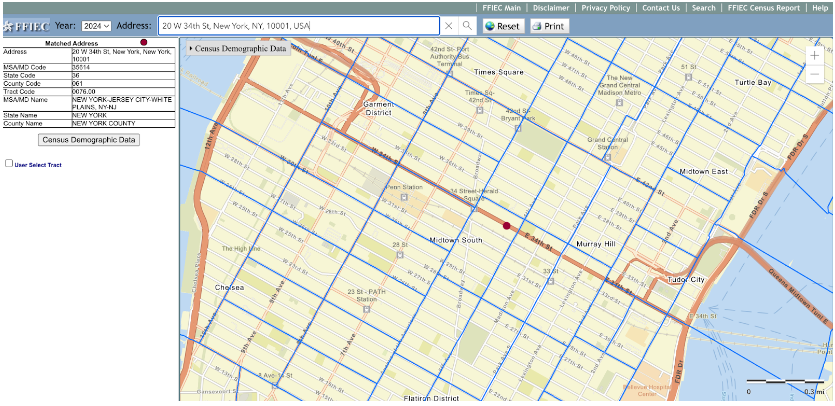
The FFIEC Geocoding System serves as a one-at-a-time online entry tool. All you need to do is add the address and it will provide you with the following information under the “Matched Address” section.
- MSA/MD code
- State code
- County code
- Tract code
- MSA/MD name
- State name
- County name
For example, we entered the address of the Empire State Building and the system returned the following result.
Requirements to Obtain FFIEC Geocoding Results
To get accurate geocoding results, it is important to understand the specific requirements. Be mindful of the following.
- Enter the street address with the name of the city and state. Make sure you are adding the correct city and state combination. You don’t have to include the apartment number, avenue, or boulevard in the address.
- Adding ZIP code is optional. However, including the ZIP code will prevent confusion and the system will give precise results. If you don’t add the ZIP code, the system’s autocomplete feature will give suggestions in a drop-down format. You can choose the one you want geocode for.
For example, as you can see below, we have omitted the ZIP code from the Empire State Building address. The system suggested three ZIP codes with similar address elements.

- The address should be in a single line. Take, for instance, 20 W 34th St, New York, NY, 10001, USA.
- It is not necessary to add the complete street address like we did above. However, make it a point to add a comma after the street address to ensure address accuracy.
Also Read: Deterministic and Probabilistic MatchingHandling Unavailable Address in FFIEC Geocoding
There is a possibility that the system might not return any information for the street address you entered. This typically happens in situations when the street address was created after the database was last updated.
When the FFIEC Geocoding System can’t return geocode information for an address, it will highlight the closest location on the map. The checkbox “User Select Tract” will be enabled, allowing you to manually select the census tract by clicking inside the map. You will find the results with a blue dot, in the “Selected Tract” section on the left side of the map.
If you want the demographic information for the selected address, you can click on Census Demographic Data. You will find it on the right side of the map.
Understanding Data Accuracy and Reporting Years
Keep in mind that the information provided by the FFIEC geocode lookup pertains to CRA and HMDA reporting for the years 2015, 2016, and 2017. The 2021 Geocoding System was updated with the census demographic data based on the American Community Survey conducted between 2011-2015. The geocoding information for 2015 and 2016 will be calculated from 2010 census data. Similarly, for 2017, the system will return results based on the 2015 Census. To get accurate results, you must select the right activity year.
When a new county or state is created there are changes in the code. However, the Census Code is only updated every ten years alongside the decennial census. If you are trying to find geocode information for years after 2015, 2016, and 2017, you might not get accurate results from the FFIEC geocode lookup.
Limitations of the FFIEC Geocoding System
Fussy Geocoding
There is no doubt that the FFIEC Geocoding System is smart. However, in situations like misspelling or misplaced commas, it fails terribly. When a user enters an address with a misplaced comma or a spelling mistake, it will either return the wrong address information or display a failed look-up notification. For financial institutions like banks or insurance companies relying on it, this shortcoming can create a major problem.
Let us take an example to understand how the FFIEC Geocoding System’s inability to make changes on its own can cause problems.
Imagine a bank has to process a loan application. The borrower lives at 567 Central Farm. However, the authority mistakenly adds 567 Central Avenue as the address. The FFIEC Geocoding System upon misidentifying the address might pull out data for a different location. As a result, the bank might end up giving the loan to a property in a different jurisdiction. When discovered, it could tarnish the bank’s reputation and develop a sense of mistrust among the customers and regulators.
To prevent this we would recommend investing in an address verification tool with geocoding API that will verify, validate, and standardize data for maximum accuracy.
Rural Routes or P.O. Boxes Not Covered
The geocoding FFIEC doesn’t provide information for any P.O. boxes or rural areas. Without accurate geographical information, the financial institution might be unable to assess loan distribution which is necessary to stay CRA-compliant. Moreover, this will hinder its ability to demonstrate that it is meeting the credit needs of all the communities, especially in underserved rural populations.
Lacks Information On Latitude and Longitude
If you look up the definition of geocode system, the search result will return the following,’ tool to transform physical address to longitude and latitude.’ The FFIEC Geocoding System provides all the address details except the coordinates.
We agree that it is not mentioned in the FFIECA geocoding requirements, however, knowing geographic coordinates can aid financial institutions. Aside from keeping them CRA-compliant, it can help with better market analysis and risk assessment. The banks or insurance companies can understand the risk associated with lending in specific regions. It will also assist them in recognizing local needs and offering tailored loan products.
No Application Program Interface (API)
FFIEC doesn’t offer geocoding API. For financial institutions dealing with large data sets, going back and forth on the FFIEC website can be a time-consuming process. A geocoding API can enhance operational efficiency by seamlessly integrating with the existing infrastructure. All you have to do is send a geocoding request to the API, and it will instantly provide rooftop geocodes.
Lack Of Bulk-Uploading Feature
FFIEC Geocoding System has no feature for providing geocodes of multiple addresses in one go. You will have to add an address individually for every person and then copy and paste the result into your sheet. Financial entities like banks or insurance companies can’t afford to waste time on these manual tasks. This is where a geocoding API can prove helpful. It will allow searching geocoding information for multiple addresses in one sweep, thus saving time.
PostGrid Geocoding API: A Comprehensive Alternative to FFIEC Geocoding
Why should you be bogged down by the cons of using FFIEC Geocoding, when you have PostGrid’s geocoding API?
We offer USPS CASS-certified geocoding API as a part of our address verification service. We verify addresses against the USPS database which means you can be sure of the accuracy of the latitudes and longitudes. Moreover, we process the address through the National Change of Address database, to ensure you always get the up-to-date geocode details.
With our geocoding API, you can search geocodes for the national or international addresses of more than 245 countries in real-time. Moreover, whether it is a rural area or a PO Box, we will provide you with longitudinal and latitudinal details of every address.
Our API outperforms FFIEC geocoding with its ability to handle inaccurate information. Even with misspelling or inaccurate information, you will get the most accurate results within seconds.
With PostGrid, you can leverage different types of geocoding- from reverse, international, rooftop to subaddress. You will get address details down to the apartment number. This can be especially helpful to financial organizations reporting to FFIEC. It will ensure accuracy when submitting the address of the person or the organization that took mortgages, or loans.
You also get on-demand and bulk address verification and geocoding. You can check geocodes for more than 200,000 addresses at a time. This can be helpful for financial institutions that have to report the accurate details of multiple loans and mortgages.
Conclusion
The FFIEC Geocoding System is built to help financial institutions meet their legal requirements for reporting on various applications for loans and mortgages. However, it has its disadvantages. It doesn’t display geocode for rural areas or P.O. boxes lack API and are error-prone. This is where PostGrid’s address verification with a geocoding API can help you. Our cost-effective API will ensure that you get the most accurate details in real time for national and international addresses. Eager to know how our geocoding API works? Request a demo and find out.
Frequently Asked Questions
What is Forward Geocoding and Reverse Geocoding?
When a physical address is converted to coordinates, i.e. longitudes and latitudes, it refers to forward geocoding. Reverse geocoding, on the other hand, refers to converting coordinates into physical addresses.
Is Geocoding a GIS?
No, geocoding is a component of GIS. Geographic Information System(GIS) is a computer-based tool using which users can map, analyze, and visualize data related to the surface of the Earth. Geocoding is a process that transforms physical addresses into geographical coordinates. A GIS uses geocoded data to create maps, understand spatial relationships, and visualize patterns with geographical context.
What is the Difference Between Geocoding and Georeferencing?
Geocoding is a computational process that converts an address into coordinates, i.e. latitude, and longitudes. Georeferencing, on the other hand, is putting the raster image (the images that you zoom until they pixelate) or vector data (points or lines) on the accurate place of Earth using a coordinate system.
How do I Find the Geocode of an Address?
You can use a geocode API to find the geocode of an address. PostGrid’s geocode API offers both forward and reverse geocoding. You can convert physical addresses into coordinates and vice versa.
Is FFIEC Geocoding Free to Use?
Yes, you can visit the official website of FFIEC and check the geocode information of any location for free.
How Often is the FFIEC Geocoding Data Updated?
The Metropolitan Statistical Area (MSA) is updated annually. However, the census tract code, the unique number that identifies a region when taking a census, is updated every ten years. When using the FFIEC Geocoding System, make sure you add the correct activity year.